
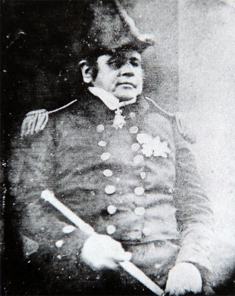
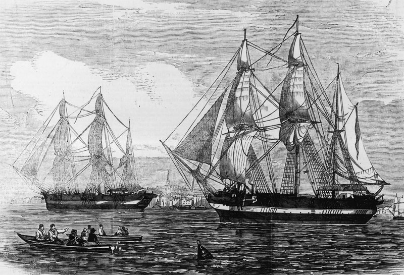
Captain Sir John Franklin departed England in 1845 aboard two ships, HMS Erebus and HMS Terror, and was ordered to traverse the last un navigated sections of the Northwest Passage in the Canadian Arctic and to record magnetic data to help determine whether a better understanding could aid navigation.
The expedition met with disaster after both ships and their crews, a total of 129 officers and men, became icebound in Victoria Strait near King William Island in what is today the Canadian territory of Nunavut. After being icebound for more than a year, Erebus and Terror were abandoned in April 1848, by which point two dozen men, including Franklin, had died. The survivors, now led by Franklin's second-in-command, Francis Crozier, and Erebus's captain, James Fitzjames, set out for the Canadian mainland and disappeared, presumably having perished.
 |
 |
Pressed by Franklin's wife, Jane, the Admiralty launched a search for the missing expedition in 1848. In the many subsequent searches in the decades afterwards, several artifacts. from the expedition were discovered, including the remains of two men, which were returned to Britain. A series of scientific studies in modern times suggested that the men of the expedition did not all die quickly. Hypothermia, starvation, lead poisoning or zinc deficiency and diseases including scurvy, along with general exposure to a hostile environment while lacking adequate clothing and nutrition, killed everyone on the expedition in the years after it was last sighted by a whaling ship in July 1845. Cut marks on some of the bones recovered during these studies also supported allegations of cannibalism reported by Franklin searcher John Rae in 1854.

The Northwest Passage was not navigated by boat until 1906, when Roald Amundsen traversed the passage on the Gjøa.
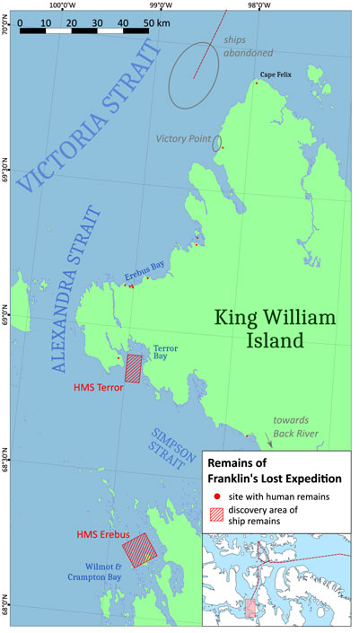
In 2014, a search team led by Parks Canada located the wreck of Erebus in the eastern portion of Queen Maud Gulf. Two years later, the Arctic Research Foundation found the wreck of Terror south of King William Island, in the body of water named Terror Bay. Research and dive expeditions are an annual occurrence at the wreck sites, now protected as a combined National Historic Site.
Franklin's Expedition
In 1804 Sir John Barrow became Second Secretary of the Admiralty, a post he held until 1845. Barrow began pushing for the Royal Navy to find a Northwest Passage over the top of Canada and to navigate toward the North Pole, organising a major series of expeditions. Over those four decades explorers including John Ross; David Buchan; William Edward Parry; Frederick William Beechey; James Clark Ross (nephew of John Ross); George Back; Peter Warren Dease and Thomas Simpson led productive expeditions to the Canadian Arctic. Among those explorers was John Franklin, who first travelled to the region in 1818 as second-in-command of an expedition towards the North Pole on the ships Dorothea and Trent.
Franklin was subsequently leader of two overland expeditions to and along the Canadian Arctic coast, in 1819–1822 and 1825–1827. By 1845 the combined discoveries of all these expeditions had reduced the unknown parts of the Canadian Arctic that might contain a Northwest Passage to a quadrilateral area of about 70,000 sq mi. It was in this unexplored area that the next expedition was to sail, heading west through Lancaster Sound, then west and south – however ice, land and other obstacles might allow – with the goal of finding a Northwest Passage. The distance to be navigated was roughly 1000 mile
In 1845, Sir John Barrow was 82 years old and nearing the end of his career. He felt that the expeditions were close to finding a Northwest Passage, perhaps through what Barrow believed to be an ice-free Open Polar Sea around the North Pole. Barrow deliberated over who should command the next expedition. Parry, his first choice, was tired of the Arctic and politely declined. His second choice, James Clark Ross, also declined because he had promised his new wife that he had finished polar exploration. His third choice, James Fitzjames, was rejected by the Admiralty for his youth. Barrow also considered Back but thought he was too argumentative. Francis Crozier, another candidate, declined out of modesty. Reluctantly, Barrow settled on the 59-year-old Franklin.
The expedition was to consist of two ships, HMS Erebus and HMS Terror, both of which had been used for James Clark Ross' expedition to the Antarctic in 1839–1843, during which Crozier had commanded Terror. Franklin was given command of Erebus, with Fitzjames as the vessel's second-in-command; Crozier was appointed his executive officer and was again made commander of Terror. Franklin received command of the expedition in February 1845.
Erebus (378 tons bm) and Terror (331 tons bm) were sturdily built and well equipped. Steam engines were fitted, driving a single screw propeller in each vessel. The ships could make 4.0 kn on steam power, or travel faster under wind power. Other advanced technology in the ships included reinforced bows constructed of heavy beams and iron plates, an internal steam heating system for the comfort of the crew in polar conditions, and a system of iron wells that allowed the screw propellers and iron rudders to be withdrawn into the hull to protect them from damage.
The ships also carried libraries of more than 1,000 books and three years' supply of food, which included tinned soup and vegetables, salt-cured meat, pemmican, and several live cattle. The tinned food was supplied from a provisioner, who was awarded the contract on 1 April 1845, a mere seven weeks before Franklin set sail.. He worked frantically on the large order of 8,000 tins. The haste required affected quality control of some of the tins, which were later found to have lead soldering that was "thick and sloppily done". Most of the crew were English, many from Northern England, with smaller numbers of Irish, Welsh and Scottish members. The only officers with experience of the Arctic were Franklin, Crozier, Erebus First Lieutenant Graham Gore, Terror assistant surgeon Alexander McDonald, and the two ice-masters, James Reid (Erebus) and Thomas Blanky (Terror).
The expedition set sail from Greenhithe, Kent, on the morning of 19 May 1845, with a crew of 24 officers and 110 men. They sailed to Greenland with HMS Rattler and a transport ship, Barretto Junior; the passage to Greenland took 30 days. At the Whalefish Islands in Disko Bay, on the west coast of Greenland, ten oxen carried on were slaughtered for fresh meat which was transferred to Erebus and Terror. Crew members then wrote their last letters home, which recorded that Franklin had banned swearing and drunkenness. Five men were discharged due to sickness and sent home .In late July 1845 the whalers Prince of Wales (Captain Dannett) and Enterprise (Captain Robert Martin) encountered Terror and Erebus[28] in Baffin Bay, where they were waiting for good conditions to cross to Lancaster Sound. The expedition was never seen again by Europeans
Only limited information is available for subsequent events, pieced together over the next 150 years by other expeditions and interviews with Inuit.
The only first-hand information on the expedition's progress is the two-part Victory Point Note (see below) found in the aftermath on King William Island. The Victory Point Note was found eleven years later in May 1859 by William Hobson (lieutenant on the McClintock Arctic expedition) placed in a cairn on the north-western coast of King William Island. It consists of two parts written on a pre-printed Admiralty form. The first part was written after the first overwintering in 1847 and the second part was added one year later. From the second part it can be inferred that the document was first deposited in a different cairn previously erected by James Clark Ross in 1830 during John Ross's Second Arctic expedition – at a location Ross named Victory Point.
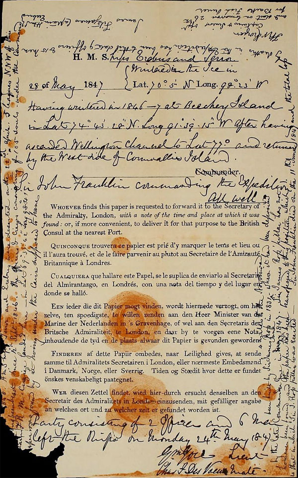
The first message is written in the body of the form and dates from 28 May 1847
H.M.S ships 'Erebus' and 'Terror' wintered in the Ice in lat. 70 05' N., long. 98 23' W. Having wintered in 1846–7 at Beechey Island[a], in lat. 74 43' 28" N., long. 91 39' 15" W., after having ascended Wellington Channel to lat. 77°, and returned by the west side of Cornwallis Island. Sir John Franklin commanding the expedition. All well. Party consisting of 2 officers and 6 men left the ships on Monday 24th May, 1847. (Signed) GM. GORE, Lieut. (Signed) CHAS. F. DES VOEUX, Mate.
The second and final part is written largely on the margins of the form owing to a lack of remaining space on the document. It was presumably written on 25 April 1848.
25th April 1848 H.M. ships 'Terror' and 'Erebus' were deserted on the 22nd April, 5 leagues N.N.W. of this, [hav]ing been beset since 12th September, 1846. The officers and crews, consisting of 105 souls, under the command [of Cap]tain F.R.M. Crozier, landed here in lat. 69˚ 37' 42" N., long. 98˚ 41' W. [This p]aper was found by Lt. Irving under the cairn supposed to have been built by Sir James Ross in 1831–4 miles to the Northward – where it had been deposited by the late Commander Gore in May June 1847. Sir James Ross' pillar has not however been found and the paper has been transferred to this position which is that in which Sir J. Ross' pillar was erected – Sir John Franklin died on the 11th June, 1847; and the total loss by deaths in the expedition has been to this date 9 officers and 15 men. (Signed) JAMES FITZJAMES, Captain H.M.S. Erebus. (Signed) F.R.M. CROZIER, Captain & Senior Offr. and start on tomorrow, 26th, for Back's Fish River
In 1854, Rae, while surveying the Boothia Peninsula for the HBC, discovered further evidence of the expedition's fate. Rae met an Inuk near Pelly Bay (now Kugaaruk, Nunavut) in April 1854, who told him of a party of 35 to 40 white men who had died of starvation near the mouth of the Back River. Other Inuit confirmed this story, which included reports of cannibalism among the dying sailors.The Inuit showed Rae many objects that were identified as having belonged to members of the Franklin expedition. In particular, Rae bought from the Inuit several silver forks and spoons later identified as belonging to Franklin; Fitzjames; Crozier; and James Walter Fairholme and Robert Orme Sargent, two crewmembers from Erebus. Rae's report was sent to the Admiralty, which in October 1854 urged the HBC to send an expedition down the Back River to search for other signs of Franklin and his men
In April 1859, sled parties set out from Fox to search on King William Island. On 5 May, the party led by Lieutenant William Hobson discovered the Victory Point Note, which detailed the abandonment of Erebus and Terror, death of Franklin and other crewmembers, and the decision by the survivors to march south to the mainland. On the western extreme of King William Island, Hobson also discovered a lifeboat containing two human skeletons and relics from the Franklin expedition. In the boat was a large amount of abandoned equipment, including boots, silk handkerchiefs, scented soap, sponges, slippers, hair combs and many books. Elsewhere, on the island's southern coast, McClintock's searchers found another skeleton. Still clothed, it was searched, and some papers were found, including a seaman's certificate for Chief Petty Officer Harry Peglar of Terror. However, since the uniform was that of a ship's steward, it is more likely that the body was that of Thomas Armitage, gun-room steward on Terror and a shipmate of Peglar, whose papers he carried. McClintock himself took testimony from the Inuit about the expedition's disastrous end.
In 1981, Owen Beattie, a professor of anthropology at the University of Alberta, began the 1845–1848 Franklin Expedition Forensic Anthropology Project (FEFAP) when he and his team of researchers and field assistants travelled to King William Island, traversing the island's western coast as Franklin's men did 132 years before. FEFAP hoped to find artifacts. and skeletal remains in order to use modern forensics to establish identities and causes of death among the lost 129 crewmembers. Although the trek found archaeological artifacts. related to 19th-century Europeans and undisturbed disarticulated human remains, Beattie was disappointed that more remains were not found. Examining the bones of Franklin crewmen, he noted areas of pitting and scaling often found in cases of vitamin C deficiency, the cause of scurvy. After returning to Edmonton, he compared notes from the survey with James Savelle, an Arctic archaeologist, and noticed skeletal patterns suggesting cannibalism. Seeking information about the Franklin crew's health and diet, he sent bone samples for trace element analysis. The analysis would find an unexpected level of 226 parts per million (ppm) of lead in the crewman's bones, which was ten times higher than the control samples, taken from Inuit skeletons from the same geographic area, of 26–36 ppm. In June 1982, a team made up of Beattie and three students was flown to the west coast of King William Island where they retraced some of the steps of McClintock in 1859 and Schwatka in 1878–79. Discoveries during this expedition included the remains of between six and fourteen men in the vicinity of McClintock's "boat place" and artifacts. including a complete boot sole fitted with makeshift cleats for better traction.
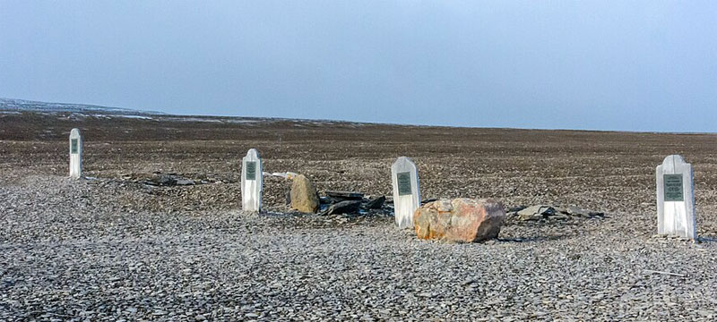
Beattie decided to examine the graves of the buried crewmen on Beechey Island. After obtaining legal permission, Beattie's team visited Beechey Island in August 1984 to perform autopsies on the three crewmen buried there. Although the autopsy indicated that pneumonia had been the ultimate cause of the crewman's death, lead poisoning was cited as a contributing factor. During the expedition, the team visited a place about 1 km north of the gravesite to examine fragments of hundreds of food tins discarded by Franklin's men. Beattie noted that the seams were poorly soldered with lead, which had likely come in direct contact with the food. The release of findings from the 1984 expedition and the photo of Torrington, a 138-year-old corpse well preserved by Arctic permafrost, led to wide media coverage and renewed interest in the Franklin expedition. Subsequent research has suggested that another potential source for the lead may have been the ships' distilled water systems rather than the tinned food. K. T. H. Farrer argued that "it is impossible to see how one could ingest from the canned food the amount of lead, 3.3 mg per day over eight months, required to raise the PbB to the level 80 μg/dL at which symptoms of lead poisoning begin to appear in adults and the suggestion that bone lead in adults could be 'swamped' by lead ingested from food over a period of a few months, or even three years, seems scarcely tenable." In addition, tinned food was in widespread use within the Royal Navy at that time and its use did not lead to any significant increase in lead poisoning elsewhere
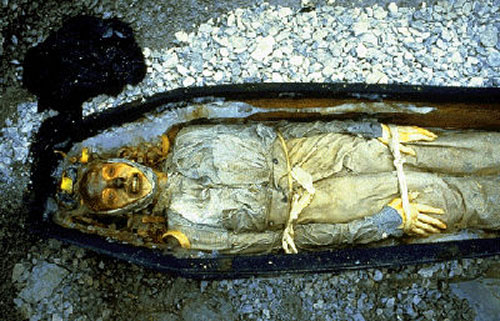
The Beechey Island bodies have been incredibly well preserved in the permafrost
In September 2014, a search by a Canadian team under the banner of the "Victoria Strait Expedition" found two items on Hat Island in the Queen Maud Gulf near King William Island:, a wooden object, possibly a plug for a deck hawse, the iron pipe through which the ship's chain cable would descend into the chain locker below; and part of a boat-launching davit bearing the stamps of two Royal Navy broad arrows. On 9 September 2014, the expedition announced that on 7 September it had located one of Franklin's two ships.The ship is preserved in good condition, with side-scan sonar picking up even the deck planking. The wreck lies in about 11 m of water at the bottom of Wilmot and Crampton Bay west of O'Reilly Island. On 1 October at the House of Commons, Canadian Prime Minister Stephen Harper confirmed the wreck was that of HMS Erebus . Parks Canada announced that Erebus had deteriorated significantly. The underwater exploration in 2018 totalled only a day and a half due to weather and ice conditions and was to continue in 2019. Also in September 2018, a report provided specifics as to ownership of the ships and contents: the United Kingdom will own the first 65 artifacts brought up from Erebus, while the wreck of both ships and other artifacts will be jointly owned by Canada and the Inuit.
In September 2016, it was announced that the Arctic Research Foundation expedition had found the wreck of HMS Terror to the south of King William Island in Terror Bay at a depth of 24 m and in "pristine" condition. In 2018, a team examined the wreck of Terror using a remotely operated underwater vehicle (ROV) that collected photos and video clips of the ship and a number of artifacts. The group concluded that Terror had not been left at anchor, since anchor cables were seen to be secured along the bulwarks.
The FEFAP field surveys, excavations and exhumations spanned more than ten years. The results of this study showed that