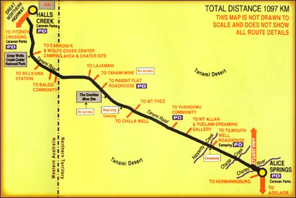
Alice Springs - Yuendumu 289km
Yuendumu - Rabbit Flat 311kn
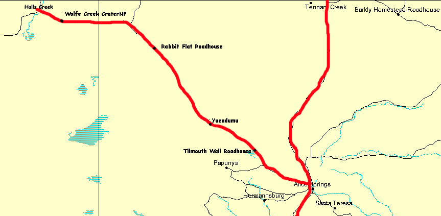
Rabbit Flat - Halls Creek 453km
The Tanami Road, also known as the Tanami Track and the McGuire Track, follows a cattle droving route northwest from the MacDonnell Ranges area of central Australia just north of Alice Springs to Halls Creek in the Kimberley. Along its route are Yuendumu and the Granites Mine owned by Newmont Mining. In the Northern Territory it passes through land owned by the Aboriginal Warlpiri Nation, and in Western Australia it passes through pastoral land.
Like most europeans do, we went along the Tanami Track in local winter time. No overnight capabilities at Rabbit Flat in winter unless you have a motor home, so my recommendation is to leave Alice Springs early in the morning 6am and arrive at Halls Creek at 8pm, having enough time to visit Wolfe Creek and some other locations nearby the track. Wonderful sky, the most beautifull ever seen and landscape. Do it. Jose, Madrid Spain.
Before you leave home, get a pass so you can visit The Tanami Desert Wildlife Sanctuary. Here you'll find lots of native animals and a true cultural experience. It's certainly a good stop off along the way. Ian, Brisbane.
The track is a graded, dirt road and although navigable by two-wheel drive vehicles, a four-wheel drive is recommended. Some parts of the road are prone to severe corrugations, making for an uncomfortable and slow drive at times. Much of the trip travels through the Tanami Desert which tends to be very flat, a little lifeless and widely home to spinifex and saltbush. Many travellers have dismissed the Tanami Track as being monotonous and boring, but it does have some interesting features along the way. The aboriginal communities along the way also produce some exceptional art, which you´ll find on display at roadhouses.
You should also carry enough drinking water to last two trips because all dams and bores along the route are classified as 'undrinkable'.
In the past traveling The Tanami Track was a horror trip. These days it is in somewhat better condition as it is the main supply route for some of the gold mines in the area as well as occasionally being used by road trains. It can still be rough though with, at times, little traffic. You could well encounter plenty of bulldust and loose sand, especially on bends in the road.
The track starts just north of Alice Springs left off the Sturt Highway. The early stretch of about 30 plus km takes you past Mt Everard and Mt Solitaire before coming to the Kimoth Bore. The road is sealed and fairly good until you reach the turnoff to the Papunya Aboriginal Community, about 120 km from The Sturt turnoff. You should now be heading for the Tilmouth Well Roadhouse, about 50km from the Papunya turnoff.
From time to time you will see tracks branching of the Tanami, many of them lead to Aboriginal communities and require permits to access them. It is not advised to be tempted to stray down them. Firstly you probably don't have the required permits and secondly the tracks can deteriorate very rapidly.
Tilmouth Well. Located 206 km from Alice Springs (50km past the end of the bitumen) between Alice Springs and Rabbit Flat, Tilmouth Well provides fuel service 7 days a week. Carrying adequate fuel and water supplies is essential. Tilmouth Well, on the edge of Napperby Station, is a refreshing change for travellers tired of the usual outback stops. You can buy fuel (leaded, unleaded and diesel). Sprawling lawns, restaurant and bar, pool, BBQ, airconditioned cabins, camping area, plus a wide variety of activities, all set on a working station. The roadhouse is situated on the banks of the Napperby Creek and, after good rain, the nearby Lake Lewis can be an attraction with wide varieties of birdlife.
Yuendumu. Beyond Tilmouth the road is graded regularly, but this doesn't seem to settle the corrugations and sandy patches. It's 102km to Yuendumu, an Aboriginal community that you'll need a permit to visit unless you're only stopping to refuel (leaded, unleaded and diesel) or to stock up on provisions at the store which is open Monday - Friday 8.30am - 5pm, Saturday - Sunday 9am - 12pm. Travelling in the direction of Alice to Halls Creek it is in this area that you will see the Wailbri Ranges to the left and the Ngalurbindi Hills to the right (in a northerly direction).
About 30km out of Yuendumu ther is a turnoff to the Vaughan Springs Home Stead. Whilst the homestead is about 80km to the south of the Tanami, you are able to get emergency fuel and supplies there as well as camping and other accomodation. Approximately 220km nort of the Vaughan HS turnoff you will start seeing the remnants of The Granites goldfields. You will spot several remnants lying around that are relics of the past. They are out of bounds though. Mining has been carried out in this area since the early 1920's and a little further on you will come accross the present day Granites Goldmine which started operations in the mid 1980's. Unfortunately the public are prohibited from entering the mining area, unless in absolute emergency, so you won't be able to see any of it in action.
The road isn't too bad for the most part, but you will need to be on the alert for washouts and gutters. If you're looking for somewhere to stop, note that camping is prohibited in the Tanami Desert Wildlife Reserve.
From here you will be heading further north to the Rabbit Flat Roadhouse.The distance is about 50 km from Granites Goldmine and about 2km off the main track. Whilst you can buy basic fuel and other provisions here when it is open, it is very expensive and credit cards are not accepted.
Rabbit Flat. The longest stretch without fuel is 315km from Rabbit Flat Roadhouse to Yuendumu. Rabbit Flat Roadhouse is only open from Friday to Monday, so if you are travelling at any other time your distance without fuel will be around 550km, Yuendumu to Billiluna. Check the latest situation by phoning the roadhouse on (08) 8956 8744. Opening hours (when it is open) are 7am - 9pm. You can also camp at Rabbit Flat on Friday, Saturday and Sunday nights only - it's bush camping with access to toilets and showers, for a small fee. If you anticipate that you will require fuel when the roadhouse is closed, you will need to call on open days to make prior arrangements.
Beyond Rabbit Flat the route normally deteriorates, with rocky outcrops to the Western Australian border and drifts of sand with high build-ups in the centre of the road. The Tanami Mine is 43km from the roadhouse, just before the turnoff to Lajamanu (a track that will eventually take you to Darwin), and the border is 78km from there. Gold was mined here, on and off, from the early 1920's to the mid 1990's.Soon after the mine you will come accross a road junction, where the road to the right, leads to Hooker Creek, some 250km north of this point, and still in the Northern Territory. You need to head left and west however towards the border of the Northern Territory and Western Australia, which is not far away, about 80km.
Balgo. About 90km from the border there is a road off to the south that leads to the Balgo Aboriginal Community. Whilst the public are welcome to visit the community and view their art gallery as well as top up on fuel and basic provisions it is a condition of entry that you contact them prior to arriving. Their contact number is (08) 9168 8900.
Sturts Creek. 70km on and you will arrive at Sturts Creek. Be wary, if there has been rain the creek can flood and make a crossing difficult. It is an excellent camping spot though and this may be the time to relax and unwind for a while before heading on the home stretch to Halls Creek.
Billiluna. A couple of kilometers or so past Sturts Creek you will see a turnoff to the Billiluna Aboriginal Community that has a roadhouse come store, basic supplies of provisions, some repairs and fuel. If you need to contact them in advance their number is (08) 9168 8988. It is at Billiluna that the Tanami meets the Canning Stock Route. If you haven't had enough yet head south onto the Canning. Fuel (unleaded and diesel) and food are available at Billiluna, the last before you reach Halls Creek. It's open Monday - Friday 8am - 12pm and 1pm - 4pm. Closed Saturday, Sunday and Public Holidays. Will open on these days before 6pm - $10 fee or after 6pm - $20 fee.
Wolfe Meteorite Crater. By now you are heading almost due north on the last leg of your journey and about 45km from Billiluna is the turnoff to the Wolfe Meteorite Crater National Park. This crater is labelled the best example of such a crater in the world. It stands about 35 meters high and is a staggering 800 metres in diameter. Many maps still show Carranya Station, 35km away at the turnoff to the Wolfe Creek Crater National Park, as having a roadhouse but if you rely on it you'll be disappointed - it closed down a few years ago. The national park is 23km off the road. Rough camping available.
North of the Wolfe Meteorite Crater turnoff travel for a little over 100 kilometres and you will reach a tar road, The Great Northern Road. You are about 15km from your final destination - Halls Creek. Turn south and you are heading for Fitzroy Crossing and ultimately Derby, Broome and Perth.
Halls Creek. With a population of around 1200, Halls Creek is the largest settlement between Derby and Wyndham and the administrative centre of the region. Facilities include hotels, motels, a caravan park, fuel (leaded, unleaded, diesel and LPG), mechanical repairs, shops, a supermarket, restaurants, police, hospital, post office and a tourist centre.
A gold find at the Elvire River in 1885 resulted in 2,000 miners rushing to
Old Halls Creek (situated just outside the modern town of today). At Old Halls
Creek you can see the ruins of the old post office and a small cemetery and
some prospectors are still finding gold around the area.
Several significant natural rock formations are readily accessible from Halls
Creek. The formation known as 'China Wall' can be seen on the way to Old Halls
Creek about 6km north of the town. It is a sub-vertical quartz vein which projects
above the surrounding rocks and is believed to be part of the largest single
fault of its type in the world.
Kimberley Hotel Halls Creek The 4 star Kimberley Hotel is located adjacent to the airport and approximately 500 metres from the town centre. The Kimberley Hotel offers unique stylish accommodation featuring the largest motel units in the Kimberley.Set in delightful gardens, with verandah's and pathways that connect the accommodation building to the reception complex. Features include an attractive colonial style Sports Lounge, Saloon Bar, Cocktail Bar and ala carte restaurant. The hotel complex boasts great views of the surrounding country side.Extensive glazing compliments the adjacent swimming pool, spa and outdoor dining area.