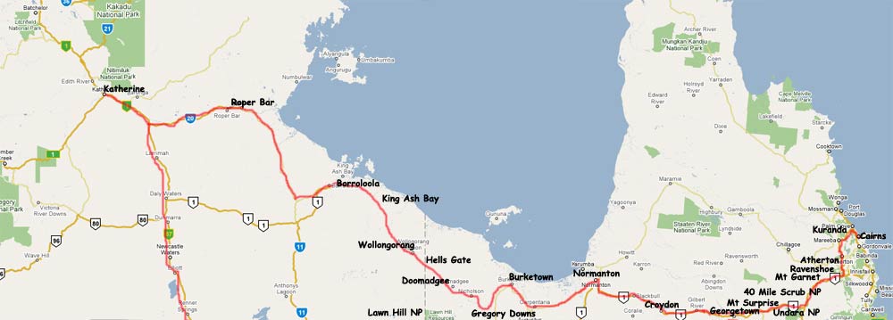
| From | Distance (km) | Driving time |
| Cairns to Normanton | 715 | 7-10 hours |
| Normanton to Borroloola | 713 | 8-10 hours |
| Borroloola to Katherine | 510 | 6-7 hours |
Savannah Way web site Open Road Savannah Way
The selection of places to visit along the way is extensive and highlights include the Undara Lava Tubes near Mt Surprise, the historic towns of Croydon, Normanton and Georgetown, the hidden gorges of Lawn Hill, other spectacular national parks
Day : Cairns to Undara
Thala Beach
Lodge, 85 rooms, is 16 kms south of Port Douglas (c.15 mins by
regular shuttle) and about 38 kms from Cairns. Thala Beach Lodge accommodation
grade category is Deluxe. This discreet, world class property is one of the
most lovely and private beach hotels in Australia. Thala Beach Lodge is set
on the northernmost headland of a 2km stretch of wonderful coastline. It has
panoramic views from the restaurant taking in the far North Queensland coast
from Double Island to Cape Tribulation, and from the sparkling waters of the
Great Barrier Reef to the World Heritage forests that cover the coastal ranges.
Thala Beach Lodge is host to more than 101 species of bird and 34 varieties
of butterfly . The accommodation is in beautifully appointed, air-conditioned
bungalows up in the tree canopy, with private verandahs. Each has a stunning
view of the exotic, tropical land and seascape. As well as 2 kms of private
beach there are 2 swimming pools. The relaxed ambience at Thala Beach Lodge
is a reflection of the natural environment in which it is situated and the natural
materials used in all the buildings.
Head to Undara via Atherton Tablelands.
Mai Tai Resort, Port Douglas Mai Tai was voted "Best Hidden Gem" - in the South Pacific for 2006 & 2008 by Tripadvisor Travellers Choice & ranks in the top 10 of best places to stay in Port Douglas. Situated high up in the clouds Mai Tai commands some of the most spectacular views in the region. With our high altitude you can always be guaranteed of peaceful days and cool breezes. Mai Tai offers a stress free environment and total relaxation. Situated an hour north of Cairns and only 10 minutes north of Port Douglas
Port Douglas Cottage These two, completely private, stand-alone, 5 star Port Douglas accommodation hideaways are architecturally designed and constructed in the traditional Queenslander style. They are the only two, self-catering accommodation retreats in the centre of Port Douglas to each have exclusive use of their own private heated pool, sundeck and BBQ.Nestled in a lush, vibrant tropical garden that retains some of the original giant rainforest trees, both the Cottage and the Lodge have their own individual tropical character.
Wanggulay House Port Douglas Sitting on the hillside above the river the luxurious pole home is filled with exotic oriental furniture, polished hardwoods, elegant fabrics, handsome statues and lush tropical plants. Nearby, the Great Barrier Reef, World Heritage rainforests, the vibrant city of Cairns and tropical beaches lined with coconut trees. Wanggulay is a place to relax and enjoy the tranquility of the forest. Just ten minutes away from Palm Cove
Kuranda. Experience the magical journey of travelling to Kuranda, by choosing a scenic rail trip, cableway or drive through World-Heritage listed rainforest to the northwest of Cairns. Kuranda, the 'village in the rainforest', is nestled in on the banks of the Barron River and is famous for its markets, delighting visitors who pick their way through stalls terraced among the trees - showcasing local products from didgeridoos and damper to art, craft and local fashions. Indigenous culture, legends and lifestyle give the village an ancient feel.
Atherton is a prosperous and bustling town set in the green, cool oasis of the Tropical Tablelands just over an hour from Cairns. With all the services you need, including restaurants, galleries, motels, caravan parks and licensed clubs, it also boasts modern shopping facilities and numerous parks and gardens. Over 60 volcanoes created the landscape of gentle rolling hills and hundreds of waterfalls running over cliffs of basalt columns. Highland rainforest still covers large parts of the Tropical Tablelands and it is home to a great diversity of ancient fauna and flora. Quaint little townships, authentic markets and friendly people welcome travelers for a rest.
Atherton Retreat Allawah Retreat's romantic luxury Atherton Tablelands Accommodation nestle on 150 acres of Australian native bush high on a ridge overlooking the picturesque Atherton Tablelands, in the Cairns Highlands and located only 1 hour's scenic drive from Cairns in Tropical North Queensland, Australia. The romantic self contained lodge accommodation with heated deck spas and private plunge pool offers privacy, peace and tranquility for couples with mountain walking tracks and panoramic views across the Atherton Tablelands. The accommodation has private self contained lodges for couples. The elegant and spacious lodges are free flowing in design and tastefully furnished with handcrafted timber furniture.
Ravenshoe, the highest town in Queensland at 930 metres, is a lush region of mountain pastures and unspoiled World Heritage rainforest. Situated 5 kilometres from Ravenshoe you will find windmills that are 46 metres freestanding and twenty of them together is a spectacular sight to behold and has become a popular tourist attraction. The windmills were built to provide the district with an alternative and environmentally power supply. In 1987 when World Heritage listing of the Wet Tropics occurred Ravenshoe was a timber town and the local Information Centre has a wealth of information about the area, a very good display on the history of the timber cutting days, and a unique exhibit of the area's nocturnal animals that include 12 species of native possum. Just 25km south of Ravenshoe, on an unsealed road you can take a short walk to overlook the impressive 293 metre Tully Falls at Tully Gorge.
Mount Garnet. Mount Garnet is one of those towns that is easy to pass through without stopping. But if take some time you'll find some amazing characters and a fascinating history. Don't miss Wurruma Swamp, just before entering the town from the north there is a dirt road which heads east to Wurruma Swamp. Although little known, this is one of the wonders of the Mount Garnet area. The swamp retains water long after other local wetlands have dried up and it draws an amazing range of birdlife. At certain times of the year there are literally thousands of black swans.
Innot Hot Springs, just west of the Atherton Tablelands is famous for its unique natural thermal mineral springs. Up until the 1900's, the mineral water was bottled in the old Innot Bottle and sent to Europe for use in medicinal purposes. Mules also hauled the water over the Cardwell range to Townsville for bottling at the Innot cordial factory. The water of the thermal mineral spring has proven its healing qualities for over a century. The spring has been developed so that persons who wish to use the waters may benefit.
40 Mile Scrub National Park. The Scrub is a rare and relatively unique vine thicket that sits on a recent cap of volcanic basalt flow. Part of the Undara Lava Fields, the thicket includes bottle trees and giant fig trees and is home to possums, gliders, wallabies and a large number of birds usually associated with rain forest.
Undara Volcanic National Park, 275 km southwest of Cairns, is one of Australia’s greatest geological wonders, boasting the best preserved and largest lava tubes system on earth. Ancient roof collapses of the tubes have created fertile pockets where rainforest plant, insect and animal species now thrive. The Undara Volcanic National Park lies within the Mc Bride volcanic province where there were 164 volcanoes, vents and cones within the area. Undara spilled out enough liquid to fill Sydney Harbour three to four times and the flow to the northwest for 164km is considered the longest single lava flow from one vent in the world in modern geological time.A Savannah Guide Station, Undara Experience, offers a variety of touring options.
Undara Experience Neither hotel nor resort, Undara Experience is a wilderness experience totally in contrast to today’s modern accommodation. Guests revisit a bygone era with authentic turn-of-the-century railway carriages that have been beautifully restored and now rest under tall shady gum trees alongside an old teamsters trail. Or alternativey they offer Swags Tent Village, Like camping without roughing it? Then ‘Swags’ is ideal. Newly refurbished large and comfortable permanent tents in a shady bush setting.
Day: Undara Volcanic National Park
Day : Undara to Forsayth (Cobbold Gorge)
Mount Surprise, set on the banks of Elizabeth Creek is a centre
for gem fossicking to O'Briens Creek with quantities of topaz, quartz, spinel,
garnet, cairngorm and aquamarine to be found. Excellent gem displays are available
at the businesses in the town as well as access to guided tours of the fossicking
in the region. The Savannahlander also passes through Mount Surprise. Bedrock
Village is a Savannah Guides site. O'Briens Creek Gem field near Mount Surprise
is well known for gem quality topaz and attracts visitors from all over Australia
and overseas. A fossicking license is required and can be issued by the Mining
Registrar in Georgetown, from a number of businesses in Mount Surprise or at
the campground. Camping is not permitted in the fossicking area, however, the
landholder of Mount Surprise Station allows camping nearby, at a site adjacent
to Elizabeth Creek with basic toilet and shower facilities for a small fee.
Georgetown is the home of TerrEstrial - The Ted Elliot Mineral Collection - a world-class mineral collection of over 3000 specimens from the region and throughout the world displayed in the TerrEstrial building on Low Street. An excellent base for exploring the by-ways in the region, it was once the center for the Etheridge Goldfield which was known as the 'poor man's goldfield' because the fossicker could find nugget gold that could be surface collected. Remains of these old sites are scattered and it is possible to find the odd nugget. A fossicking permit is required. The district boasts a wide variety of bird-life, call in at the information centre to find out the best places to spot them.
Forsayth, 20 km south of Georgetown, is at the end of the old Chillagoe to Forsayth railway which was originally built to transport gold-bearing ore from the Etheridge Goldfields to the crushing batteries of Chillagoe. The Savannahlander Train now travels from Cairns to Forsayth. A marvellous collection of agates and thunder eggs are on display at the Goldfields hotel. The Agate Creek Mineral Reserve and Cobbold Gorge tours can be accessed from here.
The Agate Creek Mineral Reserve is world renowned for agates of superb colours and patterns. Displays of the agates are on display at the Goldfields Hotel in Forsayth. To fossick for agates, a fossicker's license is required. Camping is not permitted in the fossicking area, but camping facilities are available nearby.
Cobbold Gorge, 55 minutes from Forsayth, is located on a privately owned family cattle property and can only be accessed on a guided tour. Visitors are taken through the narrow, meandering gorge on electrically driven boats. Sheer cliffs, perhaps a crocodile, birds and fish all add to a geological experience created by earthquakes. Take the alternative route via the Lynd Junction and you pass through the historic mining towns of Einasleigh and Forsayth. Cobbold Gorge is located just 45 kilometres south of Forsayth. A variety of tours of the Gorge are available with your own Savannah Guide.
Day : Forsayth to Normanton
Croydon is 562 kilometres west of Cairns. The Croydon Historic
Village contains what is left of a much larger gold mining city of the late
1800s. It had its own aerated water factories, gas lamps lighting the streets,
two foundries, coachbuilders and town criers. The town is the eastern terminus
of the Gulflander train. Two museums have been established displaying the early
mining machinery from the age of steam. Walking tracks provide visitors with
an insight into local environs. Lake Belmore is the largest body of fresh water
in the central Gulf Savannah and a great place for a refreshing dip. Croydon
also has a large sporting complex under lights. There is a hotel and a caravan
park with bathroom and laundry facilities. Croydon has medical services, banking
facilities and a general store where food, fuel, maps, drinks, tyres and batteries
can be purchased.
Around 30km to the south-west of Normanton is Camp 119, Burke and Wills’ most northerly camp. The wetlands between Normanton and nearby Karumba are also excellent for birdwatching, particularly just after the summer `wet season.’
Normantom is the major business centre in the Gulf. Visit historic buildings including the Penitentiary, where legend has it that the last Gulf hanging took place. The area has a number of good fishing spots and make sure your camera is ready for the wide array of bird life. The historic 'Gulflander' train (Savannah Guides) runs from the original railway station to Croydon every Wednesday, returning to Normanton on Thursday. Charter rides are also catered for. Have your photo taken next to the 'Big Barramundi' and 'Krys the Savannah King', a life size replica of the largest crocodile ever caught. Accommodation available in Normanton includes hotels, motels and caravan parks. Fuel, mechanical repairs, medical facilities, banking facilities and food are all available in Normanton. Fishing tours on the Norman River can also be done with a Savannah Guide.
Day : Normanton to Hells Gate
The Savannah Way from Normanton to Borroloola is unsealed and suitable only
for 4WD vehicles. Rich in flora and fauna this region boasts one of the world's
oldest landscapes.
Burketown sits on the Albert River and on the east - west-dividing line between wetlands to north and the beginning of the savannah grass plains. Established in the 1860s as a supply town for cattle farmers it is the oldest town in the Gulf area. The town is a major service centre for the region's cattle industry and is the entrance to the Gulf of Carpentaria, 25 km away by boat. Burketown is an interesting region to visit all year, however during the monsoon season transportation methods must be carefully considered as roads in the western Gulf Savannah region are largely unsealed. Burketown is the best location to view the unique Morning Glory cloud formation during the months of September to October. The town boasts to being the Barramundi capital of the world and hosts the World Barramundi Championships each Easter. There are a number of other activities that can be enjoyed while in Burketown such as bird watching, bush walking, camping, station activity and fishing. Fuel, medical facilities, banking facilities, mechanical services, food and airport are all available in Burketown.
About 5km out of Burketown is the turnoff to Escott Lodge, a cattle station offering accommodation, meals, camping facilities, fuel (leaded and diesel only) and fishing activities in which you can participate. It's an easy journey from here to Burketown, a small but important administrative centre for the region. It has the usual town facilities including banking agencies and a hospital as well as myriad things to see and do.
Recommended side-trip from Burketown to Lawn Hill National Park (via the township of Gregory). This community on the banks of the Gregory River is too beautiful to pass by. Situated 117km south of Burketown, Gregory lies on the intersection of the road to Lawn Hill National Park. The river has wide sandy banks, the water is cool and clear and the vegetation on the banks is thick and lush, the remnants of the ancient rainforest which once covered the entire Gulf Savannah. The river is spring-fed from limestone country and is fast-flowing, crystal clear and excellent for swimming. The Gregory River is also considered on of the best canoe courses in Australia and is the venue for the annual Gregory Canoe Race on the long weekend in May and attracts many top canoeists. As the river is the only main water source in the area a great selection of marsupials and birds live in the area making it a great place for wildlife photography as well.
Gregory.This community on the banks of the Gregory River is too beautiful to pass by. Situated 117km south of Burketown, Gregory lies on the intersection of the road to Lawn Hill National Park. The river has wide sandy banks, the water is cool and clear and the vegetation on the banks is thick and lush, the remnants of the ancient rainforest which once covered the entire Gulf Savannah. The river is spring-fed from limestone country and is fast-flowing, crystal clear and excellent for swimming. The Gregory River is also considered on of the best canoe courses in Australia and is the venue for the annual Gregory Canoe Race on the long weekend in May and attracts many top canoeists. As the river is the only main water source in the area a great selection of marsupials and birds live in the area making it a great place for wildlife photography as well.
Adels Grove (Savannah Guides) is the service centre for visitors to Lawn Hill National Park and is located only 10 km by road from this unique and magnificent gorge. Camping facilities are also available here. Advanced bookings are essential, through Adel's Grove, phone (07) 47485502, or email. We could only visit Lawn Hill as day vsitors, as the camping area there was full. (They always advise booking ahead.) We took a few nice walks through forest to the Cascades and to Indarri Falls, but we didn't have the ambition to walk as far as the Upper Gorge or take a canoe through the Middle and Upper Gorges, but everyone said that was the best way to see the area. You can bring your own canoe or hire one there for quite reasonable rates. We stayed overnight about 10 km away, at Adel's Grove, a spacious and nicely laid out camping area in wonderful grounds. They have good showers and toilets but no mains electricity (using a generator for power) or drinking water (bring your own or boil their river water). Fortunately they turn the generator off at 9 p.m., so it wasn't noisy at night. Early in the morning, as we boiled the billy, an agile wallaby visited us.
Boodjamulla (Lawn Hill) National Park. Situated 120 km south of Burketown, Boodjamulla (Lawn Hill) National Park is an oasis for weary travellers. This spectacular gorge has to be seen to be believed. The gorge with its 60 metre sheer sandstone walls and crystal clear green is fringed by lush tropical vegetation including livistona palms, Leichhardt trees, paperbarks, figs, pandanus, and white cedar trees - remnants of the ancient rainforest that covered the Gulf Savannah millions of years ago. Wildlife is also abundant and includes agile wallabies, solitary wallaroo, insectivorous bats, olivine python, fairy martins, water monitors, tortoises, and a variety of birdlife. Twenty kilometres of marked pathways provide access to the more spectacular viewing areas around the gorge area. From Lawn Hill it is possible to access the World Heritage listed Riversleigh Australian Fossil Mammal Site.
Riversleigh - World Heritage, comprises the southern section of Lawn Hill National Park. More than 250 fossil sites have been discovered in 10,000 ha of rough, inaccessible terrain. The Riversleigh fossil deposits are among the richest and most extensive in the world, with some fossils dating back to the Oligo-Miocene time, some 15-25 million years ago. D-Site, the only area open to the public, was one of the first fossil deposits found and gives visitors an opportunity to view fossilised mammals and reptiles in situ. The Riversleigh Fossil Centre provides an extensive insight into the region as it was 25 million years ago, and into the process of fossilisation
Just 50 kilometres inside the Queensland border and 145 kilometres northwest of Burketown on the unsealed road is Hell's Gate Roadhouse. The roadhouse is the gateway to the Macassan coast and provides air-conditioned accommodation motel units with touch dial phones, budget accommodation and a campground. Hells gate roadhouse also provides icy cold drinks, cool crisp salads, fuel, minor mechanical repairs and licensed facilities. Savannah Guides conduct full day, half day & 2 hour tours, giving the opportunity to see the station at work, enjoy the bird life and the natural wonders around Hell's Gate, the aboriginal art and Afghan Camp. Take a tour of historic Westmoreland Station or experience the beauty of Hell's Gate by air, enjoy a scenic flight to Kingfisher camp.
Doomadgee, situated on the Nicholson River, between Burketown and Hell's Gate, is an Aboriginal community engaged in the cattle industry. The Aboriginal mission of Doomadgee was originally established on the coast near Burketown 1931, the settlement was moved inland to its present location after a cyclone in 1936 made conditions on the coast impossible. Today the town has a population of 1200 of whom 1100 are Aborigines. The main area of the community is accessible to visitors. There is a general store in the town, which provides the traveler with both food and fuel. There is minimal accommodation and no eating facilities.
Doomadgee to Borroloola is 398km. Overall this stretch is a good, wide, earth-formed carriageway. You'll need to take care at the creek crossings - some of them can be particularly nasty after rain.Some of the stations around this part of the Gulf allow camping and fishing on their land and in their rivers. All they ask is that you report to the relevant homestead upon arrival. The section of track between Doomadgee and Wollogorang had huge amounts of money spent on it in upgrading and is now a fairly decent bit of road, although potholes can still take you by surprise after rain.
From Doomadgee to Hell's Gate, it's 81km where you can buy food and fuel supplies. It's open Monday and Wednesday to Friday, 8 am-4.30 pm, Tuesday, 10 am-4.30 pm and Saturday, 11 am-12.30 pm.
Day : Hells Gate to Borroloola
Wollogorang Roadhouse is situated about 5km from the Queensland border on the enormous Wollogorang Station, a cattle station which takes in approximately 7000km² of Gulf country. Open daily (6 am-9 pm), its facilities include fuel (unleaded and diesel), accommodation, a licensed restaurant, supplies and some camp sites. The roadhouse can also organise safaris and fishing tours, or you may like to get off the beaten track by yourself. A 4WD track cuts across the property to the Tully and Massacre Inlets on the Gulf coast - magnificent, pristine places where the fishing is good and there are plenty of places to camp. This track is only accessible by permission from the roadhouse and a nominal fee will be charged. Watch out for saltwater crocodiles!
Borroloola is a remote fishing community beside the McArthur River in the gulf region of the Northern Territory. It is famed for unique history, characters and excellent fishing. Many visitors use Borroloola as a base for barramundi fishing expeditions. The town is an ideal location to stock up before exploring the gulf region. A major attraction in the region is the Sir Edward Pellew group of islands. The Borroloola Museum was once the old police station built in 1886. There is a collection of artefacts, documents and photographs that detail Borroloola's interesting past including the influence of the Macassan (Indonesian) contact in the earlier part of last century. For information on this region, contact the Katherine Region Tourist Association tel: 1800 653 142, The Borroloola Tourist Information Centre is located in the council offices just inside town.
King Ash Bay 52 kilometres from Borroloola and 30 kilometres inland from the Gulf of Carpentaria is the King Ash Bay Boat and Fishing Club – a primary destination for visiting fishermen and the host of the annual Borroloola Fishing Classic. Access to the lovely offshore Sir Edward Pellew Islands is also possible from King Ash Bay where excellent fishing opportunities also abound.
For the last 100km or so, the road is reasonably straight and runs through densely timbered areas. The last river of any note that you'll cross is the Wearyan.
Day : Borroloola to Katherine via Roper Bar
Borroloola to Roper Bar. Caranbirini is a small conservation reserve located
46 km south of Borroloola on the western extremity of the Bukalara Range. The
nature reserve has unusual sandstone escarpment and spire 25 metres in height.
The area includes some aboriginal art sites, a waterhole and a range of endangered
species. The Reserve also protects a number of habitats and plays an important
role in preserving the region's unique flora and fauna as it is located within
the ecological transition zone between the tropical north and drier centre.
Roper Bar, the small community is situated on the tidal pandanus-fringed Roper River, renowned for plentiful stocks of barramundi and saratoga. Visit Lomarleum Lagoon with its splendid cover of brightly coloured, blooming waterlilies. About 25km downstream is the wreck of the Young Australian which was used for towing large sailing vessels carrying supplies for the Overland Telegraph Line in 1872.
Cape Crawford is situated near the intersection between the Carpentaria and Tablelands Highway. Lindsay Crawford was the drover who discovered the so called 'Lost City' in the nearby Abner Ranges in 1880. The Lost City covers and area of about eight square kilometres and is dotted with towering sandstone formations. These natural pillars remind many observers of skyscrapers. The ominously named 'Heartbreak Hotel' has campsites, a pub and motel. Helicopter tours are run out of the area to the Lost City while further north, Lorella Springs and Limmen Bight Fishing Camp has camping facilities, fuel, provisions and fishing. The Roper is a popular fishing base and the last place to refuel before Mataranka (Open Monday to Saturday, 9 am-6 pm, Sunday 1pm-6pm). There is also a store, motel accommodation and campsites. Note that alcohol is not available at Roper Bar and is prohibited in the surrounding Aboriginal communities.
Further north, Limmen Bight Fishing Camp has camping facilities, fuel, store and fishing operators.
Katherine is a bustling trade town in the heart of the top end. Home to over 10,000 people, highlights include the Springvale Homestead, NT Rare Rocks, the Katherine Museum, Katherine School of the Air and Katherine Springs.
Dazzling scenery, a unique history and all types of adventure await visitors in the spectacular Katherine Region. The area surrounding the township of Katherine is one of the most historically significant in the Territory. The Jawoyn people first settled the area thousands of years ago. What is now known as the Katherine River provided them with an abundance of food and water and was the foundation of their culture. Ludwig Leichhardt was the first European to visit the area during his 1844 expedition to Port Essington where he discovered the headwaters of the Katherine River but it wasn’t until 1862 that the river was named by the explorer John McDouall Stuart. He named it after Catherine, the daughter of his benefactor, James Chambers. The name was misspelt and has remained that way ever since. With the establishment of the Overland Telegraph Station at Knott’s Crossing (where the original pylons can still be seen) the town boomed.
Katherine is a multicultural community and the friendly locals welcome you to their town. Historical sites such as the beautiful Springvale Homestead are managed by the National Trust and provide a meaningful insight into the early pioneer days. The museum and several exceptional art and craft galleries display authentic Aboriginal art, contemporary and historical pieces. For geology buffs, NT Rare Rocks showcases unusual gemstones, ore specimens and other local rocks.
Nitmiluk (Katherine Gorge) National Park is one of the Territory's top tourist
attractions. The majestic 3,000 square kilometre park is owned and run by the
area’s traditional owners, the Jawoyn people. Nitmiluk means Cicada Dreaming
– and comes from an important local Dreamtime story.
Here the Katherine River flows through 13 spectacular gorges separated by rapids
and carved through the Arnhem Plateau before heading northwest to the tidal
Daly River and the Timor Sea. You can canoe, cruise and swim between sheer cliffs
to the sandy freshwater beaches of the main gorges and ancient Aboriginal rock
paintings high on rock faces. Breathtaking waterfalls and crystal clear rock
pools are hidden in the gorge’s nooks and crannies and over 100 kilometres
of walking tracks begin at the park’s highly informative visitor centre.
Spectacular escarpments, gorges, hot springs, waterfalls and swimming holes
insure the area’s enduring popularity as a holiday destination.
The magnitude of the area is best gauged with a scenic helicopter flight over
the gorges.
If you make the trip to nearby Edith Falls, you'll find another tranquil setting for swimming and hiking. The Daly River and the Douglas Daly Region (best known for its hot springs and Butterfly Gorge) are also popular places for campers and fishing trips.
For a truly intrepid adventure, fishing fanatics can head east along the Carpentaria Highway to the Gulf of Carpentaria or west along the Victoria Highway to the mighty Victoria River. These rugged regions challenge even hardy adventurers and their wild waterways team with barramundi and other big catches.
Day : Katherine
The most significant tourist attraction near Katherine is the 180,000 hectare
Nitmiluk (Katherine Gorge) National Park, located 32 kms northeast of Katherine.
The Gorge is actually made up of 13 separate gorges. The park offers a range
of activities, so you can spend the day swimming, bushwalking, boating canoeing,
helicopter joy flights etc.
There are 13 gorges in the system carved out of ochre sandstone and separated by rapids. The Gorge can be explored by cruise boats, canoes, fixed wing and helicopter flights, bushwalking and swimming. Walk for 66km along the Jatbula trail to Edith Falls, cruise the Gorges on a 2,4 or 6 hour cruise, or just have lunch at the Nitmiluk Visitor Centre. You can finish your top end exploration today by driving north from Katherine to Darwin (316 kilometres, approximately 4 hours drive).
Nitmiluk National Park
The star attraction is Nitmiluk National Park, just 29km from the town centre,
where the Katherine River carves a deep gorge through towering red sandstone
cliffs to form 13 spectacular gorges each separated by a tumble of boulders
and a string of rapids. During the wet season, November through to April, the
river is a raging torrent of water-borne fury fed by the torrential rains that
lash the Top End during the summer, but during the dry season you can hire canoes
or take one of several cruises and explore the gorges.
Cruising
Cruises range from two-hour trips through the first two gorges, to eight-hour
safaris through five of the gorges. On the longer trips there is time to swim,
explore, or just relax in the shade by the river. All trips include some walking
and rock-hopping between gorges so remember to wear comfortable and sturdy walking
shoes and pack plenty of sunscreen. The best time to go is during the late afternoon,
when you'll get the best photo opportunities as the walls of the gorge glow
a deep and vibrant red.
Swimming
There is a nice swimming platform near the visitor's centre in the park, and
the river is supposedly free of saltwater crocodiles: the only ones they say
you'll see here are the relatively harmless freshwater variety. Although large
saltwater crocs have been caught just a few kilometres upstream, there are several
traps near the swimming area that apparently keep the killers at bay.
Another good place to swim is at Leliyn (Edith Falls), located on the western boundary of the park. The paperbark and pandanus fringed natural pool at the base of the falls is safe for swimming most of the year.
Kakadu National Park
Wikipedea write up. Kakadu National Park is located within the Alligator Rivers Region of the Northern Territory of Australia. It covers an area of 19,804 square kilometres, extending nearly 200 kilometres from north to south and over 100 kilometres from east to west. It is the size of Israel. Kakadu National Park has some of the best examples of Aboriginal rock art in Australia. The sites of Nourlangie and Ubirr are among the most visited locations in the Park. It is possible to view some of Kakadu’s diverse wildlife at places like Yellow Water Billabong, Cooinda on board a wildlife cruise or at Mamukala Wetlands or Anbangbang Billabong. The Kakadu region is one of the world’s best for bird watching as approximately 30 percent of Australia’s bird species can be seen here.
Large saltwater crocodiles are also commonplace and visitors are likely to see them at Yellow Water and East Alligator River so it was no coincidence that the Crocodile Dundee films were shot here. Visitors are urged to exercise caution around crocodiles as they have been responsible for a number of fatal attacks.
Waterfalls tumble from the red cliffs of the Arnhem Land escarpment into shady pools; tranquil wetlands teem with animal and birdlife while 40,000 years of Aboriginal cultural heritage is on display in the numerous hidden rock art galleries. The opportunities for photography are as varied as they are spectacular. While visits to Kakadu's main attractions are on our itinerary including a cruise on Yellow Waters (a favourite haunt of saltwater crocodiles) it is when we get off the tourist tracks that Kakadu reveals its true magic. Our bushwalks are a highlight with opportunities to wander through remote gorges to sparkling waterfalls for a quick dip before heading to our overnight camp.
There are several accommodation options in the Park, mostly found in the town of Jabiru, as well as a range of services to cater to visitor’s needs. Visitors can experience Kakadu National Park with a recognised tour operator or they can drive themselves. Many of the Park’s sites are accessible by standard two wheel drive vehicles, but areas like Twin and Jim Jim Falls and Gunlom require four wheel drive vehicles. Visitors can experience Kakadu National Park via the Nature’s Way tourism drive which is a loop from Darwin to Jabiru then onto Katherine and back to Darwin covering approximately 900km.
Kanadu Lodge Kakadu Lodge is situated on the fringe of the Jabiru township, just three hours drive from Darwin, central to many of the attractions of Kakadu World Heritage Park.The fully landscaped gardens provide shady grassed camping areas and comfortable accommodation in the Lodge or self-contained cabins.There are 15 air-conditioned, Self-contained Cabins with kitchenette and ensuite bathrooms and 32 air-conditioned Lodge Rooms with communal bathroom and kitchen facilities located in a natural bush setting. Get back to nature and utilise one of 186 powered caravan sites or 100 non-powered caravan and camping sites ideal for a family getaway.Kakadu Lodge also boasts a magnificent lagoon style pool, souvenir shop and kiosk and is within walking distance of the bank, post office and local shops.
All Seasons Katherine All Seasons Katherine is located near the town centre. The hotel features a restaurant, bar, swimming pool, tennis court, BBQ area and function room. Major nearby attractions include Nitmiluk Katherine Gorge, Cutta Cutta Caves, Mataranka Springs, Umbrawarra Gorge, Edith Falls and historical Springvale Homestead.