

Relative size of Svalbard
The islands were first used as a base by the whalers who sailed far north in the 17th and 18th centuries, after which they were abandoned. Coal mining started at the beginning of the 20th century, and several permanent communities were established. The Svalbard Treaty of 1920 recognizes Norwegian sovereignty, and the 1925 Svalbard Act made Svalbard a full part of the Kingdom of Norway. They also established Svalbard as a free economic zone and a demilitarized zone. The Norwegian Store Norske and the Russian Arktikugol remain the only mining companies in place. Research and tourism have become important supplementary industries, with the University Centre in Svalbard (UNIS) and the Svalbard Global Seed Vault playing critical roles in the economy. Apart from Longyearbyen, other settlements include the Russian mining community of Barentsburg, the research station of Ny-Ålesund, and the mining outpost of Sveagruva. Other settlements are farther north, but are populated only by rotating groups of researchers. No roads connect the settlements; instead snowmobiles, aircraft and boats are used for inter-settlement transport. Svalbard Airport, Longyear serves as the main gateway.
 |
 |
After WW2, the Soviet Union proposed common Norwegian and Soviet administration and military defence of Svalbard. This was rejected in 1947 by Norway, which two years later joined NATO. The Soviet Union retained high civilian activity on Svalbard, in part to ensure that the archipelago was not used by NATO. During the Cold War, the Soviet Union comprised about two-thirds of the population on the islands (Norwegians making up the remaining third) with the population of the archipelago slightly under 4,000. Russian activity has diminished considerably since then, falling from 2,500 to 450 people from 1990 to 2010. By 2016, Svalbard had a population of 2,667 of which 423 were Russian and Ukrainian, 10 Polish, and 322 non-Norwegians living in Norwegian settlements.
Polar bears are the iconic symbol of Svalbard, and one of the main tourist attractions. The animals are protected and people moving outside the settlements are required to have appropriate scare devices to ward off attacks. They are also advised to carry a firearm for use as a last resort. A British schoolboy was killed by a polar bear in 2011. In July 2018, a polar bear was shot dead after it attacked and injured a polar bear guard leading tourists off a cruise ship. In August 2020 a Dutch man was killed by a polar bear at a campsite in Longyearbyen. The polar bear was shot dead. As of 2021, Svalbard has around 300 resident polar bears.
 |
 |
 |
 |
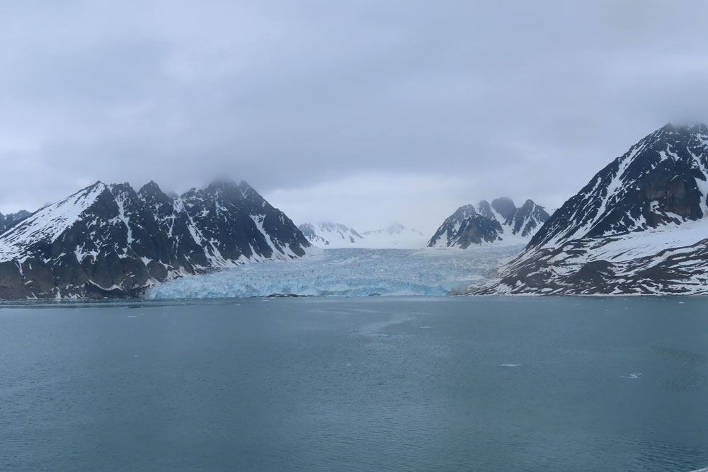
Svalbard’s Southern Region and specifically Spitsbergen’s west coast is less ice-clogged than the rest of Svalbard due to the moderating influenced of the Gulf Stream. Several fjords cut into the western coast of Spitsbergen and have been used by trappers and hunters, as well as the different mining companies that tried to exploit the riches of the archipelago’s largest island of Spitsbergen. Remains of huts and mines, as well as active commercial and scientific settlements can be found and visited. Depending on the time of the season, glaciers can be visited on foot or by sea. Hornsund will reveal fascinating views of geological formations, craggy mountains, spectacular glaciers and a variety of seabirds and seals.
Svalbard’s northern region is less influenced by the Norwegian Current coming through the Greenland Sea than the southern region and shows more ice. The northern part of the island of Spitsbergen shows quite a number of impressive fjords, bays and glaciers. The Nordaust Svalbard Nature Reserve includes Spitsbergen’s east coast, the Hinlopen Strait, Nordaustlandet and some islands further east like Kvitoya and Storoya. Several walrus haul-outs, spectacular glaciers, bird cliffs and bird islands, as well as surprising flora in Arctic deserts and the possibility to see polar bears and to visit historically important sites make this an area prone for exploration. Ice conditions will dictate which sites can be seen.
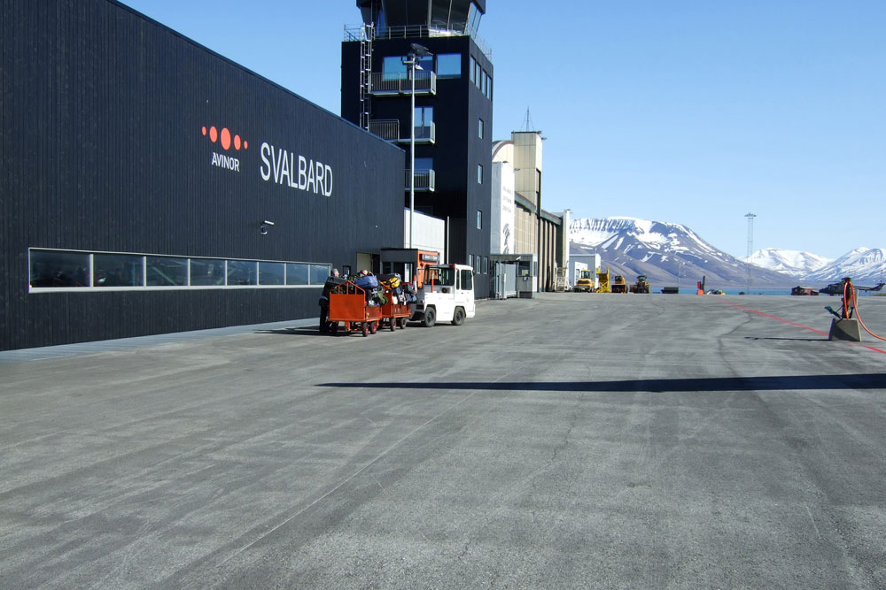
Longyearbyen is the biggest settlement in Svalbard. Seat of the Norwegian administration, it also has the best services and infrastructure in the archipelago. Located deep in the Adventfjord, a sidearm of the Isfjorden (Icefjord), Longyearbyen’s airport can be used all-year round, but its harbour is blocked by ice in winter. Most shops, hotels, restaurants and a hospital are within easy walking distance of the port. One of the most prominent buildings in town is the UNIS cent er, where several Norwegian universities have joined forces to operate and offer the northernmost higher education to both Norwegian and international students. Adjacent to UNIS, and well worth a visit, is the Svalbard Museum, covering the natural history and exploitation of Svalbard. Remnants of the former mining activity can be seen all around Longyearbyen and even in town.

It would be fair to say that most of us on the ship were there to see Polar, bears, of which we "saw" three
Polar bears
We saw 3 distant polar bears - in fact so distant that they could not be seen with the naked eye. The first photo below is by the ship's photographer, and, I do not think, is any better than mine. Basically the bears were so far away that photography was difficult. It leaves the philosophical question, as to, if we did not see them with the naked eye, then did we see them at all?.
Click on any thumbnail photo and get a larger photo
 |
 |
 |
 |
 |
 |
 |
 |
 |
 |
 |
 |
So on to the various stops
Gåshamna is a bay at the southern side of Hornsund, Sørkapp Land, on Spitsbergen, Svalbard. The bay has a width of about 2 km, and is included within the Sør-Spitsbergen National Park. Here are remains of whaling, Russian and Norwegian overwintering trapping and remains from one of the first great international research expeditions in the Arctic. The cultural remains are vulnerable. In addition, there are exquisite examples of patterned ground, and a walk on the tundra is highly recommended.
The oldest remains of human activity in Gåshamna can be dated back to the whaling era in the 1600-1700s. Whaling, which targeted bowhead whales, was concentrated in the summer season. The bowhead population around Svalbard collapsed during the 1700s and has never recovered. This is a tragic example of human overexploitation of natural resources. Blubber ovens, house sites and graves are the most important remains from the early European whaling, but bones at the slaughtering sites for whales and walruses can also be found. Between the larger structures you may find harpoons, clay pipes and pottery. About 50 whaling stations are registered in Svalbard – this site is one of the oldest, dating from the time when the industry was still land-based
There are remains of two large whaling stations in Gåshamna, one on each side of the river delta. Both stations were probably English and were in use between 1618 and 1650, when the English had claims to Hornsund. At the eastern station the remains consist of a house site, a large blubber oven and a burial ground with 12 graves at a small hilltop close to the station. In 1992 archaeologists excavated parts of the house site and the blubber oven, which proved to be very well preserved. The western station is located on the other side of the delta, in a vegetation-free area. This station was partly taken by the river in 1993, which led to an emergency excavation of the fragmented remains. The rest of the installation lies further in from the river and comprises house sites, graves and blubber ovens, which are all in relatively good condition. However, erosion is also a threat to this station.
We had a couple of hours ashore here. To me it was amazing that nothing grew around the old whaling station, but where whales had been processed, there was enough nutrient left in the soil to sustain small plant growth

Click on any thumbnail photo and get a larger photo
 |
 |
 |
 |
 |
 |
 |
 |
 |
 |
 |
 |
 |
 |
 |
Gnalodden is within a few miles of the last stop, Gåshamna
Gnålodden is a place with a lot to see within a small area. Just the rocky shoreline is a sight in itself. The flat area is of limited size, but beautifully green with its mossy tundra, a clear indication for the presence of large numbers of Brunich’s guillemots and kittywakes that breed in the steep cliffs of Gnålberget. The old hut, which was built in 1907 or 1908, is a real eyecatcher. Until the protection of polar bears in 1973, it was part of a classical polar bear hunting area. The bears came with drift ice around the south cape, up the west coast and into Hornsund. In some years, hundreds of them migrated through the fjord and back to the east coast: rich hunting grounds for trappers, including the legendary Norwegian female hunter Wanny Woldstad, who was one of the first active lady hunters in Spitsbergen when she wintered several times in Hornsund during the 1930s.
Among other things there was an Arctic Fox on the hunt : whilst I could see it (just) with my naked eye, I was not able to get a telephoto lens shot - the two I have here are from the Expedition photographer. We explored for a couple of hours, with the 5 armed polar bear guards around the perimeter, as on evey landing that we made
Click on any thumbnail photo and get a larger photo
 |
 |
 |
 |
 |
 |
 |
 |
 |
 |
 |
 |
 |
 |
 |
 |
Lloyds Hotel , Regnardneset, Mollerhamna .
In Möllerfjord, the northeastern branch of inner Krossfjord, there is a slightly peculiar hut on a small peninsula called Regnardneset. Painted in bright orange colour, it carries the proud name “Lloyds Hotel” and is decorated with 5 stars and a sign that says “Lloydagentur Möllerhafen” (Lloyd’s agency Möllerfjord). The story goes back to the German “Zeppelin expedition” in 1910, when count Ferdinand von Zeppelin was in Spitsbergen with the steamer Mainz to look for a place suitable for an airship base. Count von Zeppelin was strongly interested and involved in the development of airships, which are now connected to his name. Laughed at in earlier years, he enjoyed considerable support by 1910, even Prince Heinrich of Prussia, son of emperor Wilhelm II., was interested enough in the project to join the count on his 1910 expedition to Spitsbergen. They occupied large parts of Spitsbergen between Kongsfjord and Raudfjord, a practice which was quite common on those years, when Spitsbergen was still Terra nullius (no man’s land). Later, it should have been possible to find a good place for an airship base somewhere in this large area.
We went ashore here for a couple of hours and had long chats with 3 of the expedition staff - the only way to get to know them now with the Covid rules aboard ship. We had the structure of ice explained to us. There were all sorts of interesting additions inside the hut!. We also saw a bird's nest on the ground and Oscar's 'hanging gardens of Babylon', a small area with a myriad of tiny flowers
Click on any thumbnail photo and get a larger photo
 |
 |
 |
 |
 |
 |
 |
 |
 |
 |
 |
 |
 |
 |
 |
14 July Glacier
Fjortende Julibreen is a glacier in Haakon VII Land at Spitsbergen, Svalbard. It has a length of about sixteen kilometers, and a total area of about 127 km2. It is located between Reppingen, Løvlandfjellet and Mercantonfjellet to the south, and Casimir-Périerkammen, Forelryggen and Foreltinden to the north, and extends down to Fjortende Julibukta in Krossfjorden. The glacier is named after the National Day of France, the 14 July
We spent some time, well wrapped up, sitting on the back deck drinking up the beauty around us
Click on any thumbnail photo and get a larger photo
 |
 |
 |
 |
 |
 |
 |
 |
 |
 |
Texas Bar.
This is a cabin built in 1927, and now owned by the Svalbard governing body. We had the "surprise", which was a rum laced hot chocolate. We then walked to the top of a nearby hill, all within the "bear perimeter" that had been set up
Click on any thumbnail photo and get a larger photo
 |
 |
 |
 |
 |
 |
 |
 |
 |
 |
 |
 |
 |
 |
 |
Mushamna. glacier
We enjoyed our zodiac cruise with views of a Whiskered Seal and 2 arctic terns, all positioned on small icebergs as we approached as near as we could to the glacier edge
Click on any thumbnail photo and get a larger photo
 |
 |
 |
 |
 |
 |
 |
 |
 |
 |
 |
 |
Walrus at Smeerenburg
Smeerenburg was a whaling settlement on Amsterdam Island in northwest Svalbard. It was founded by the Danish and Dutch in 1619 as one of Europe's northernmost outposts. Whaling developed into a pelagic industry for just a short period: , Smeerenburg was abandoned about 1660.
During the first intensive phase of the Spitsbergen whale fishery, Smeerenburg served as the centre of operations in the north. The name Smeerenburg is a Dutch word literally meaning "blubber town". The whalers were taking the "Greenland right whale", now known as the bowhead whale, which were then prevalent in Fram Strait. At that time, oil was rendered from whale blubber using try pots on shore, rather than on ships at sea, so the whalers needed a shore station for the try works. Remnants of whale oil that built up around the large (ca. 2-3m diameter) copper kettles in which the blubber was rendered. Leftover blubber was used as fuel for the fires. The site of Smeerenburg was first occupied by the Dutch , when ships from the Amsterdam chamber of the Noordsche Compagnie (Northern Company) established a temporary whaling station here with tents made of canvas and crude, temporary ovens. In 1615, 1616, and 1618 the Dutch again occupied the site. In 1619, a 500-ton ship with timber and other materials was sent to Spitsbergen.[3] The tents and temporary ovens were replaced with wooden structures and copper kettles "set in a permanent fashion on a brick foundation, with a brick fireplace beneath and a chimney for the smoke."
After landing we were able to approach, quite near to, the large group of walruses
Click on any thumbnail photo and get a larger photo
 |
 |
 |
 |
 |
 |
 |
 |
 |
 |
 |
 |
 |
 |
 |
Ice Edge
Because of complaints from a vocal group, we wasted a whole day heading north through a gale to get to the "ice edge". But visibility was bad, and the sea rough, so we were never going to see a bear on the, melting anyway, pack ice. The ship wasted the morning moving along the ice edge, before giving up and heading south through the gale to get back to Svalbard. It is incredible to me that people can be bought off with this sort of carry on -"we tried". Instead we could have had another day on Svalbard, and perhaps seen something - we scarcely could have seen less than we did this day. I guess there were also "traveller" who wanted to boast that they had been north of 80 North - a meaningless virtual line.
Click on any thumbnail photo and get a larger photo
 |
 |
Gaffelbreen
The main attraction here was the "hut with a loo". The Loo being a spectacular outbuilding, with a view over the fjord. We saw lots of reindeer antlers and a few distant reindeer and had a pleasant walk about.
Click on any thumbnail photo and get a larger photo
 |
 |
 |
 |
 |
 |
 |
 |
 |
 |
 |
 |
 |
 |
 |
 |
Disembark
We were thrown a Zodiac disembark at the last minute. Silversea appear to have released their cruise itinerary before they secured a berth in Longyesrbyen. When they failed then to get a berth, they carried on with doing a disemnbark with the ship anchored some 800 metres offshore
On the disembarkation day, it was blowing a gale - so windy that planes were not able to land at Longyearbyen Airport. They started taking the baggage off early, then had to suspend zodiac operations because of the winds and swell. At 9am we were told to return to our cabins( already evacuated at 8am by edict! ) .Then by about 09.30 the Captain made the decision to get the passengers off, regardless of the conditions( he obviously knew at that time that the new incoming passengers had been allowed to take off from Oslo!!) We were loaded, 15 at a time into zodiacs, bombarded with plastic bags in an attempt to reassure us that we could stay dry!?, !and transferred the distance to the shore. The only way was at 90 degrees to the swell and wind. Which meant waves continually breaking over the passengers. Many had no waterproof trousers - having either returned rented ones to the ship, or packed them in their luggage before they knew the conditions. Something like 40 ICY waves broke over us as we headed for the shore. The water even got through my parka via the zip.
We were then herded and abandoned in a quayside wooden shack. The shore handlers did not enter, nor did Roberto, the receptionist and sole crew ashore. The buses for our "tour of Longyearbyen" did not turn up. After about 2 hours wait in the hut , without any information, a bus arrived ( aboard which the guide thought he was taking us for lunch!!) and took us the 10 minute drive to the airport
Here chaos broke out . Ponant, Lindblad and Silversea guests milled around. Nobody from Silversea organised our check in. There were only 2 of a possible four check in desks available. When we eventually did check in, security was a bureaucratic nightmare. After security, the holding area did not have enough seats. And there was no decent food available. We had no food from an 8.00 breakfast on the ship, to a 18.00 meal once we eventually got on the plane
The Lindblad rep kept his charges up to date, and also arranged food to be brought from their ship - of Silversea nothing was heard nor seen, and certainly no food was supplied
When our flight was called , we had a 400 metre walk through a gale to the plane - the wind was so strong that Chris could not stand up - and boarding of the plane so disorganised that we then waited some 15 minutes on the tarmac, in the gale
Click on any thumbnail photo and get a larger photo
 |
 |
 |
 |
 |
 |
 |
 |
 |
 |
 |
 |
 |
 |
 |
The flight took us to Oslo, overnight at Radisson Blu hotel at Oslo Airport, then back to Alicante the next morning
The final irony was we picked up Covid somewhere along the way. We left the ship on Thursday, and Chris had the first symptoms by Sunday. So it could have been from the ship (where we know that there were a number of cases among passengers and crew), or from aircraft, airports or hotel on the way back
Click on any thumbnail photo and get a larger photo
 |
 |
 |
 |
 |
Silversea never contacted passengers to apologise. The majority view of most punters was that they would never use Silversea again
An email written by me on the day after our reckless evacuation was only answered after 8 weeks and 4 days!! To my surprise, the company did actually apologise